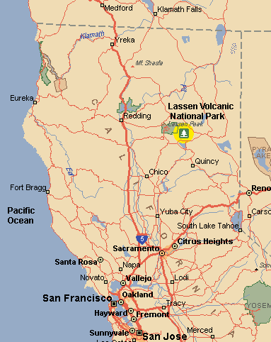
What's the best way to end the semester after the finals, after suffering through the grading process and finally submitting them? You guessed it: Pack up your gear and take off to the mountains, get some high altitude air and exercise, climb and ski/snowboard. That's exactly what son Eric and I (Udo) did. On Thursday afternoon, 2nd June 2005, we drove to Mt. Lassen and camped on the north-side in The Devastation Wilderness parking lot.
Friday, 3rd June, we used for altitude acclimatization at 6500 feet. We spent most of the day just visiting with people either going to or coming from Lassen or just ogling it. One important part was Pieps training. Eric recently acquired a Pieps (avalanche victim locator). From his friend Harry he borrowed another one. What good is it if one guy having a locator is buried and the other one doesn’t have one to find him? We took turns burying one of the locators, and the other guy had to follow a search pattern until his instrument registers. Then he has to follow a path in a direction where either the sound is getting louder or where the directional indicator points. We were pleased that within 5 minutes we found the “victim” within one foot, even when the instrument was buried underneath the ground or wedged in a crack of a huge boulder. When we returned to the parking lot our “game” turned out to be a serious preparation. One guy hobbling toward us on crutches scared the wits out of us when he told us his story for his predicament. He and 4 other skiers survived a huge multiple avalanche on the Southern face of Lassen as they skied down the day before. It appeared that they set off a Schneebrett. He had to "swim" while the avalanche tried to suck him in with his skis. The others were able to outski it. He was lucky that it only broke his leg. He had a tough time to make it down the mountain with his buddies, who then drove him to the Redding hospital.
In the afternoon we wanted to hike up the Devastated Area to the snow-line which started at about 1000 ft above the parking lot. Just when we started a ranger came by and told us that we cannot camp so close to the parking lot. So we had to waste valuable time to move the tent further into the woods. Finally, in the evening, we fulfilled our goal to hike two hours up through the woods, along a creek, through moraines to the snow-level (7500 ft) to deposit our skis/snowboard and heavy gear (like my ski-boots) so that we would have an easier ascent on the next day. We got back to the camp at 9 PM (when it turned dark). This tent moving delay cost us valuable sleep time. After making supper it was past midnight until we turned into our sleeping bags.
At crack of dawn (Saturday, 4. June 2005) Eric and I, with hardly any weight, hiked up back to our gear deposit. We went through the snowfield to a slanting ridge: Eric carrying his snow-board, Udo skiing uphill with ski-skins. Udo had troubles with one ski were the skins (lacking glue) kept coming off. Finally he also carried the skis. Eric was way ahead on the ridge with another father/son team. When Udo finally made it to the top of the slanted north ridge (about 9500 ft) practically the end of the snowline) he was surprised when Eric announced by walky-talky that he was on top of Lassen. Udo convinced himself of this fact by zooming in with his video camera on the peak. Sure enough, next to the man-made phallic-shaped structure containing weather/electronic equipment, he saw Eric balancing himself and waving from the highest outcropping. Udo figured it is not worth the 4 hour round-trip to make it to the very top, and waited there for Eric, enjoying the great view, in particular Mount Shasta looming above everything at its 14500 ft majestic height. When Eric came back both enjoyed snowboarding/skiing down. They followed a path which took them closer to the road, thus avoiding an extended trip though the woods. Due to my forfeiting the summit, we still made it to our camp before sunset.
While on the top, Eric met many climbers who made it to the top from the south-side. There the peak is only about 1 mile horizontal distance from a parking lot and with 2000 ft altitude difference (versus 5 miles/4000 ft from the Devastation parking lot). So this was our goal for the next day. Maybe I will also have a chance to summit! To be able to get up at 4 AM and not to waste time breaking the camp, we collapsed our tent this evening and slept in the car.
Sunday (5. June 2005) we got up when it was still dark. By the time we had breakfast and drove to the summit parking lot the sun was out. The first portion in the shade was still very icy (circa 8 AM). If it were not for the boot-steps on the trail one would have needed crampons. When getting to the south ridge, the snow was softening. Udo walked his usual deliberate slow-gate, while Eric was out of sight. The ridge was on the left side of the huge southern face with the three avalanches from 3 days ago in full view. I kept making small detours to the western side (left) of the ridge to search for the slopes for the return run which hopefully would be less avalanche-prone. But I couldn't see it due to volcanic outcroppings blocking my view. Two-third ways up I and another climber spotted three snow-boarders coming down the south-face. Could Eric be among them? And then a single snow-boarder schussed down! Zooming in with my video-camera I spotted Eric! We cheered for him; later Eric told us that he thought we were warning him of an avalanche. After all, he was right between the other avalanches. Then I video'd him as he was boarding down in one sweep until I lost him in my zoom. Ten minutes later my radio crackled and it was Eric announcing that he reached the S-curve of the road. It took a lot of coaxing to make him out among the trees at such a distance. It showed how hard it would be to spot a person in distress from an airplane. Finally when he kept moving back and forth on an open snow-covered meadow next to the road, I spotted him.
This scenario gave me a welcome break, and, well rested, I continued. Finally I also made it to the top saddle (it took me twice as long as Eric, who made it up in 2 hours). On a rock-outcropping other skiers/snowboarders who had passed me cowered in the wind-shadow of the rocks. I asked them which way they would go down. They all preferred the avalanche prone south face to the back descent on the west though it was noon already. Leaving my skis there I scrambled up the pile of rocks leading to the summit with the phallic structure. What a terrific view! I also saw the northern ridge, where Eric ascended yesterday. I did not have any regrets for not going on yesterday. When coming down the rocks another climber, the last one remaining on the saddle, approached me. He was quite amused by my clownish look, since I had Zinc-Oxide smeared al over my face, in an attempt to prevent sun-burn. He offered to take a photo/video of me. He was there on foot planning to glissade down on his behind. He was quite an experienced climber who visited Lassen, Shasta etc. several time. He then showed me, where the run would start going down the back-mountain (westerly), and admonished me to then curve to the left, so I wouldn’t wind up in another valley.
I started this run, but then found out that the slope consisted of solid ice, where my edges hardly dug in. The strong cold wind turned the slope to ice! Before it got too steep, where I could have slid down into a steep ravine, I decided to ski up to the saddle again. I was between a rock and a hard place: either take a chance with the ice or take a chance with the avalanche slope. I reasoned that, though it was 2 PM, the icy wind would also stabilize the top portion of the south face. Also, now I realized why the other skiers/boarders opted for the south-slope. Snow-conditions, crusted, were not the greatest in going down elegantly. One felt a little safer when going over the area where the avalanche had slid off already. However, one always had to eye the part above the 2 foot break-line. Finally when reaching the lower debris field as the slope was getting less steep, where the previous avalanches bunched up, I could relax. I was amazed that there were man-high blocks of snow & ice. The guy who got caught in it three days ago really was lucky that he didn’t get crushed by the boulders.
From here on down I could enjoy more the view around me. I got in contact again with Eric by radio who had a ball exploring a western gully, which would be great for ski-sailing (“uphill racing”) if the wind came from the correct direction. I also admired his signatures, where he carved up the surrounding mountains with his snowboard tracks. In particular a closed chain link track (he snow-boarded down the opposite mountain twice) was very noticeable. Finally I made it to the same place at the S-curve of the road where Eric wound up earlier. Eric picked me up by his SUV from there. What a great mountain experience!
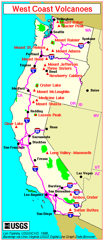
This blog should serve to share our experience with others. For our European friends/relatives I posted some maps so that they can easier find this place. When viewing the West Coast Volcano Map I realize that a few more volcanoes remain for me to climb. So far I climbed, starting from the South: Mammoth, Lassen Peak, Mount Shasta, Mount Hood, Mount St. Helens. You also can reach the top of Mammoth by ski-lift; however, with my college friend Lamar Strandtmann, we did actually climb it. The remaining ones are: Mount McLoughlin, Three Sisters, Mount Jefferson, Mount Adams, Mount Rainier and Mount Baker. Hmmm, something to dream about! Other volcanoes under my belt are Fuji and Popo. Well, to be honest, I went up on Popocatepetl until I ran out of breath. Reaching an altitude higher than Mont Blanc, when it took 2 breaths per step, I decided it would be wise to turn around. When climbing Mont Blanc with brother Dieter at a yet younger age (in the 70's) it was difficult enough to catch one's breath.


